EASTERN WASHINGTON
Summary
This trail has potential, if cleared of fallen trees, to take you up to a gorgeous ridge line in the mountains. If crews have yet to clear the blowdowns, it has the potential to test your mental fortitude along with your hip mobility and balance as you scramble over, under and around the downed trees.
Trail Stats
Mileage: 8.24 miles one way
Elevation Gain: 2,838 feet
Elevation Loss: 1,430
Toilet at trailhead: Yes
Sandwich Spots: Yes
Parking: Designated Lot
Mileage/EG from Garmin Watch

Trail Details
With mild trepidation we headed out HWY 20 toward Sherman Pass in late May. Our destination? The Kettle Crest trail. Why the uncertainty? That was multi-factorial. For starters, the weather forecast looked rather dismal. Today was supposed to reach the low 90’s and then drop down into the low 70’s and 60’s for the remainder of our backpacking trip. With rain and thunderstorms. The weather simply will not cooperate with our plans this year.

Other concerns came due to there being relatively little online information on this trail. There were no recent trail reports that we found and it was difficult to tell where there were official campsites along the way. And “they” do want passers through to only use designated sites. Turns out that was not a problem on day one.

Water was another valid apprehension. The trail is known to have little water and depending on the year’s snow pack, those water sources are dubious. This year we are already in a declared drought from having no significant snow fall. With no recent reports and having never been in the area before, we had no idea what to expect. Normally we pack into areas with reliable water sources and simply filter water as we go. With this trip we decided to lug in extra water and I planned all our meals “dry”. As in no rehydrated meals. Which means they were a LOT heavier. As was the extra water. I carried two – 3 liter water bladders, which apparently weights 13.23 pounds. Which is an insane amount of extra weight when packing everything in. Normally I only take one 3L bladder and Doug brings two standard Nalgene bottles, which is what we filter our water into.

As it turns out, we did find a nice flowing water source, where we did in fact filter water, and also a few less appealing options that would do in a pinch. Though I would have likely added an iodine tablet just to make sure. Nothing quite like a murky stagnant puddle to make you question your choices. All that being said, most of the water sources were trickles. One “spring” that we saw on a map was already dry. Which did make us question how long these water sources will be available this year. We’d had a lot of rain in the few days prior to us heading out, not sure if that added to the general availability of water or not. To note, there are no water sources at the Wapaloosie trail junction.

The Kettle Crest Trail itself spans 44 miles from White Mountain (south of Sherman pass) to Boulder Creek (north of Sherman Pass). This trail is part of the Pacific Northwest National Scenic Trail, which will take you from the Olympic National Park on the WA peninsula to Glacier National Park in Montana. That trail is 1200 miles long. We had no intention of completing either trail. We just wanted a nice sampling.

That being said, we chose to begin our quest at Sherman Pass. The pass is the highest year-round maintained pass in WA state, claiming to be at 5,575 feet at the highest point in the road. It’s a well maintained and the trailhead is directly off HWY 20, making accessibility a breeze. There is a large parking area and a single, remarkably clean loo. Must have recently been painted as there was no graffiti inside. There was one other vehicle in the parking lot, though we never saw anyone on the trails.

Now. Onto the trail. It’s well marked. You’d be blind to miss it. Walk back up the gravel road for a minute. There are two trails. Both are for the Kettle Crest Trail. One is South and one is North. We headed uphill to the north. Very shortly into the trail you’ll pass under some power lines. The trail is mostly in the woods. At first, it started out remarkably well. Trail was in excellent condition. There were intermittent huckleberry bushes and wildflowers along the path. Then we started hitting downed trees. Nothing major. Just a tree here and there. Not a big deal to step over or walk around. The trail maintains your interest with interspersed large, mostly granite, boulders and rock faces amongst the trees.

At some point we heard military jets. The annoying thing with these guys is they come out of nowhere and disappear before you can get your phone out to snap a photo. And it can be difficult to spot exactly where they are as the noise is briefly deafening. Regardless, Doug absolutely loves them and becomes like a giddy school boy. I think they are pretty awesome but my level of excitement is markedly less than Doug’s. After straining our necks skyward for a bit it was back to walking.

Very quickly the trail transitions into gentle switchbacks up the mountainside. At 1.3 miles into the hike we came across our first water source. A tiny trickle of a stream. Around here there were some decent views into the Colville forest and the surrounding mountains. At 1.5 miles into the trail there was a small spring, which was noted on our map. At 2.1 miles up the trail there was a dry water basin just off the trail.

Near here, there is an optional offshoot trail. This trail is the Columbia mountain Loop trail. We declined and pressed on. Around 3 miles there was a better water source, more liquid and better flow. 3.3 miles in there was a lovely potential camping area. This would be a great spot if you drove in late and just wanted to pack in a bit before dark. Or if you’d come from further down the trail I suppose. If that one was full there was a flat rocky area about 0.2 miles further that one could potentially set up a tent in quite easily.


As I previously mentioned, there were blowdowns on the trail. They went from being cute little one tree nuisances to pure multi tree’d menaces. As is 5-10 trees in a giant wide tangle. Which meant some climbing over, crawling under and trail rerouting to pass by. Which got rather annoying and tiring after a bit. Great for testing out your hip mobility and balance. Doug’s legs are quite a bit longer than mine. What he could clear was not necessarily what I could clamber over well. And stepping from tree trunk to the next with a loaded pack will alter your balance. While I received a load of fresh scrapes and one stick straight up stabbed me, we came through unscathed. No one fell. No real harm. Just tired legs. And pitch on the hands from crawling under them.

By lunchtime, which was only 4.1 miles into the trail, we had already crossed 49 blowdowns. And thats just the ones we counted. If we could easily step over a log we didn’t count it. If there were multiple downed trees only a few feet apart we counted it as one. A jumble of twisted up trees counted as one. Whoever goes in to clear out that trail has a load of work to do. Better bring in a few chainsaws and lots of willing hands. At least lunch was good. One of my absolute favorites. A backpacking Banh Mi sandwich. Complete with soft jerky, pickled veggies, hoisin sauce and cilantro. Yum!

After lunch we shrugged on our packs and hit the trail which begins to head downhill. There were plenty of blowdowns along the way. At roughly 4.5 miles in there are switchbacks to descend. Within the switchbacks, roughly at 4.6 miles, theres an excellent single tent campsite. Has a killer view and a built up fire pit. Granted I’m relatively certain there were signs designating no fires or at least to make certain the fire is put ALL the way out. Not sure this is an official spot but it was obviously used plenty of times. We also heard more fighter jets during this point, they flew directly overhead.

Roughly 5.4 miles down the trail there’s a 180 degree turn. Here you’ll see a trail divert off to the right. Do not take this trail. It will lead you astray. Instead, continue down the main trail a few paces. You’ll come across a sign and another split in the trail. This is where you’ll head right to stay on the Kettle Crest Trail. It’s the path that heads uphill.

Throughout this section, the blowdowns were once again bad. All over the place and every few feet apart it seemed. Maybe a tad dramatic but there were plenty of times we would clear a large one and then 20-30 feet down the trail, come upon the next one. The worst were the ones we had to shuffle or crawl under.

Around 5.75 miles into the trail we heard water. Obvious running water sounds coming from downhill. We pressed on eagerly, just to the point where the trail begins to switchback uphill. At this bend in the trail we ditched the packs and chugged water like never before. Do remember it was rather hot. We had been rationing water up to this point just in case there were no decent places to filter. This legitimate creek is just a few paces down from the bend in the trail with clear creekside access. It was rather obvious that four legged critters use this spot to drink as well. There were plenty of deer prints along the muddy bank. Not sure if this one ever dries out. It is a very shallow creek.

After topping off all our water it was back to it. Up the switchbacks we went. There were more blowdowns. To be honest, we lost track after 106 blowdowns and gave up counting.

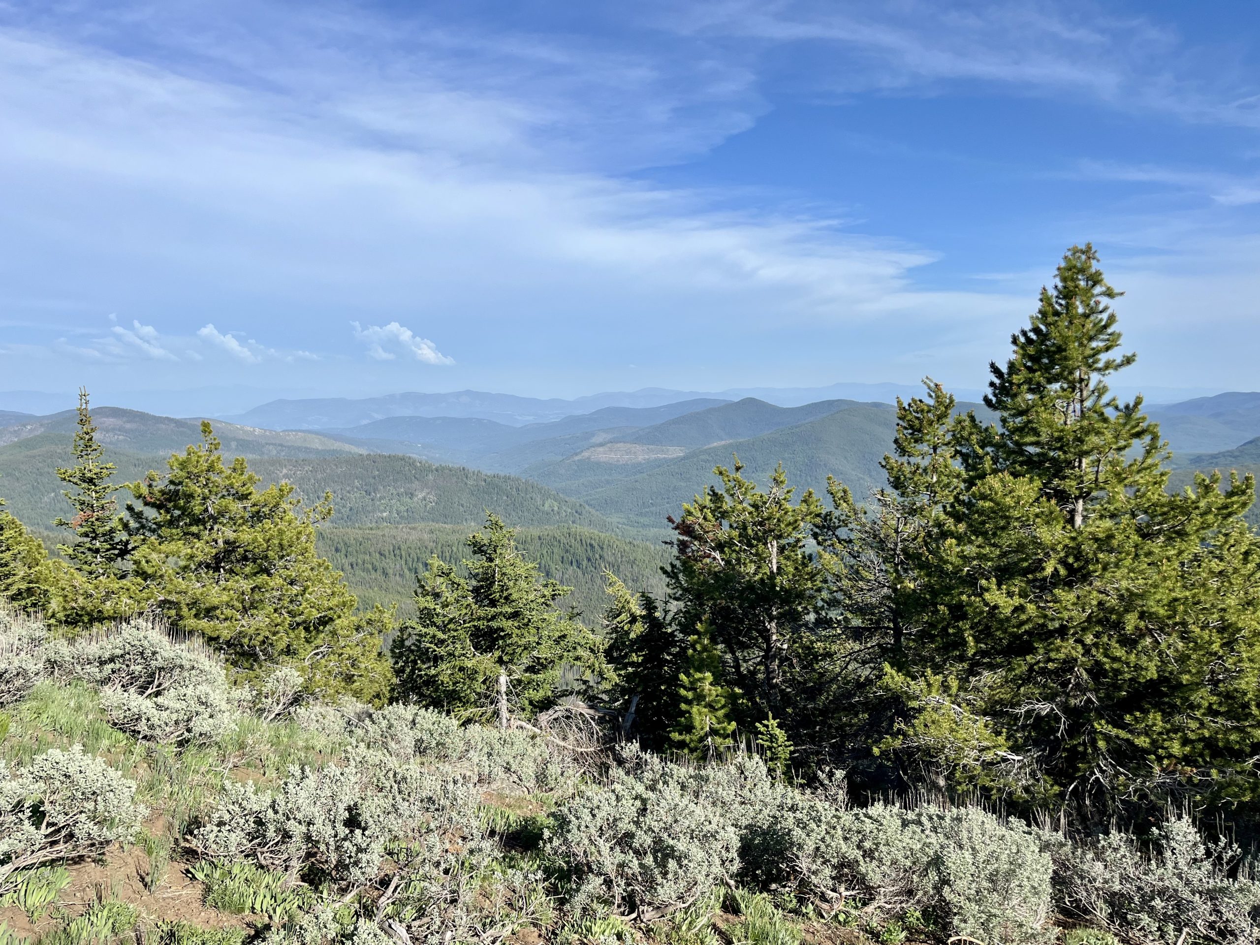
After a bit of uphill walking we passed a rocky hilltop that was fairly barren looking. A stark contrast to the forest we’ve been passing thru. The trail heads to the right of this hilltop where you’ll have peek a boo views of the surrounding mountains and valley. Remarkably, there are significantly fewer blowdowns up here.

Around 6.8 miles you’ll come to the next water source. This one was marked on all maps we looked at. It consists of a spring fed mucky meadow. The meadow is more of a bog. This is open range area. While we saw zero cows on this trip there was plenty of evidence of them. Giant cow pies all over the place. This “meadow” is obviously a watering hole for them, which is evidenced by hoof print pocked land and those droppings. I would not love filtering out of one of those wet spots. If you continue up the trail a bit there are large boulders you’ll walk through. Here there is a pipe coming out of the hillside with flowing water. Much better to filter here. Unless you like questionable cow pie water. Then by all means, test out your filter.


Just after this boggy meadow is an official camp area. There’s plenty of space for multiple tents. A few parties could easily fit in this area. Here the trail once again splits. To the left is the Kettle Crest trail. To the right is the Jungle Hill trail, which we would take on our hike out. There’s a connector trail near the bottom that will take you back to the parking lot at Shermans Pass.

At 7 miles we passed through a field containing a random pile of timbers. We supposed they were remnants of a past trail maintenance program, or perhaps for later use. Oddly enough, the meadows up here are populated with sagebrush throughout them. Not exactly something we expected to see.

Around 7.2 miles in the views significantly opened up. One can clearly see the surrounding mountains of the Kettle River Range. Finally, we reached the views everyone posts when talking about the Kettle crest trail. Could have mentioned the horrific blowdowns and that it would take you WAY longer than expected to pass through that nonsense.

Along this section of trail, there are quite a few meadows. The trees are shorter. Blissfully, there are hardly any downed trees. You’re hiking along the top of the ridge and the trail is mostly even and flat. The views are fantastic. We passed many areas that could be made into a camp site if one was desperate.

We kept going until we reached the Wapaloosie Trail junction. There’s a fantastic camp site at this junction. It’s huge. Loads of tents could fit, though the ground is not 100% flat throughout. We happily pitched our tent in a remarkably flat spot, under a few healthy trees. There was another flat spot near but it had a dead tree next to it. I originally thought to hang our bear bag in the dead tree but upon closer inspection of said tree, I realized that any decent sized critter could simply knock the tree over. Even I felt I could wiggle it a bit. Nope. Another tree was selected and Doug went to work getting the bag neat and tidy up in the tree. In theory your bag is supposed to be a minimum of 10 feet up, preferably higher. Also, the bag should be 4 feet away from the trunk of the tree. Not the easiest thing to do. If you stumble across the perfect tree it’s amazing. This one was pretty dang close. Good job Doug!

After setting up camp, significantly later than expected, it was near dinner time. We chose the extra credit route and headed over to Wapaloosie mountain, which was directly next to us. In theory there is a trail up to the top. We simply walked down the Wapaloosie trail for a bit before diverting uphill through the meadow. We loosely followed the tree line around the hillside a bit before heading into the trees. Rather quickly found the summit, marked by a pile of rocks in a small meadow. As there are trees surrounding it, the views are rather non existent from the summit. We poked around and explored a bit. Just past the summit to the north is a camping spot. Again, I am uncertain as to the officialness (totally not a word) of this site but it is there regardless. Has a fire pit and everything.

After wandering around, we headed back down toward the Wapaloosie trail. Decided to have dinner while sitting on a few nice rocks. The views from here were the best of the entire day. Great spot for dinner or lunch. I’d packed smoked salmon, crackers, apples, peanut brittle and a cliff bar for dinner. Not terrible. I like the peanut butter cliff bars. But then again, I like almost anything with peanut butter.

After dinner, it was back to camp. A quick wipe down of the face, brushing of teeth and putting everything potentially smelly up in the tree for the night. Our fatal mistake here was with our actual packs. Bear bag was nicely in the tree. I generally attach my backpack to a tree or branch. Keeps the small critters, like mice, out. There were no great branches here so we placed our bags on what I’m guessing is a tethering post for horses. Or mules. Or donkeys. I like mules. They’re snarky and stubborn. And donkeys are hilarious. Horses not so much. But I’ve had not so great experiences with them. Noting quite like a green broke horse and a timid kid who knew nothing about riding horses. That went well. Not. The error lay in those bags. Doug’s was on bottom, mine on top. What I should have done is taken out my rainfly and covered them both. Unfortunately I did not. The day had been so hot. It hadn’t rained at all. Those predicted afternoon thunderstorms had never appeared. All would be well. Or so I thought.

Inside the tent we played a few rounds of Speed followed by Gin Rummy. Soon it was dark enough to put the cards away and attempt to sleep. Which is nearly impossible when backpacking. Sunset was just after 8:30 and we were tucked into our bags shortly after 9pm.

Around 10pm we were awakened by what sounded like a freight train rushing toward us. It was a storm. I’ve never heard anything quite like it. One minute it was distant, the next we were in it. From there, we got a free light show. Lightning lit the sky and illuminated our tent every 5 seconds or so for about an hour. Crazy enough, there was no real sound to most of the flashes. Initially I thought the pattering on our tent was needles and bits of pine cone from the trees. Later I realized it was rain. By then it morphed into an impressive downpour. Which was unfortunate for our bags outside. By morning I swear they each gained 10 pounds with being so waterlogged. Oops. Luckily, our tent fared much better. We stayed nice and toasty and dry under the rainfly. Our shoes stayed dry under the vestibule. Always purchase a tent with a large enough vestibule to put your shoes and some gear under. Best if it reaches nearly to the ground. Keeps everything so much dryer.

The storm raged around us for a few hours before settling down and returning the area to a peaceful respite. I love a good storm. This was a good one. It was insane how bright it was in the tent during those flashes. Eventually I got tired of it and pulled my beanie forward over my eyes. Ahh, instant black out blinds for my eyeballs. Sleep that night was rather lousy.

We really wanted to love the Kettle Crest Trail. Pictures showed stellar views. In reality, we spent most of the day in the trees with peek a boo views at best. It’s amazing there are any trees standing with how many blowdowns we had to navigate. I believe there is a trail crew that comes out, maybe in June. If possible, I would recommend coming out here AFTER they have been out. That being said, there’s no way they could clear that many trees. You’d need multiple chainsaws and a huge crew for a few days just to clear the path to the Wapaloosie and Kettle Crest Trail junction. And thats only 8 miles in. Should you head out later in the year, bring extra water. We read plenty of reports from years past about multiple water sources people were relying on being dry and them having to go without for quite some time. That would be not so good. Especially as the trail is not the most traveled and the odds are high you’ll be out there alone. Which we love.

The trail itself is in remarkable condition, barring those downed trees. One can tell a lot of consideration went into it and it has been maintained beautifully. As there are quite a few dead trees throughout the area I do think blowdowns will continue to be quite the issue. While we were left dissatisfied with our overall experience it did come mostly from those blowdowns. If the trail had been clear, or at least 20 or less blowdowns total, the experience could have been significantly different.



Leave a Reply