CENTRAL WASHINGTON
Summary
There are numerous routes one can take around Frenchman Coulee. We chose to visit just about everything in the area, which made our map a tad chaotic. The hike provides plenty of variety with climbing up a mesa, exploring a basin, sand dunes, coulees, waterfalls and few lakes!
Trail Stats
Mileage: 10.16 miles total
Elevation Gain: 1,430 feet
Toilet at trailhead: Yes
Sandwich Spots: Yes
Parking: Designated Lot
Mileage/EG from Garmin watch

Trail Details
A brief drive outside of George, home of the gorgeous Gorge Amphitheater, lays Frenchman Coulee. Which is yet another place I’ve unknowingly driven past many times over the past few decades. Who knew George was hiding this sweet spot? Apparently rock climbers knew. The place is crawling with them. We rolled in on a Friday morning and the place was packed, or at least the camping areas were packed with overnighting climbers. Different breed of people for sure. Listening to their conversations about routes, techniques and rock ratings made my eyeballs hurt. But, as a very broad stereotype and generalization, they are delightfully nice people. And for some weird reason they actually want to desperately cling to the side of a sheer rock face. Which is never where I want to be. So, besides a full parking lot occasionally, I’m never in their way and vice versa. Great situation. Weird hobby though. But then again I love to hike and that’s essentially just going on long random walks away from and back to your vehicle. Also kind of weird if you stop and think about it.

We began our trek at the main climbers parking lot off of Vantage Road SW. Packed all our essentials and lunch in my bag and Doug loaded up the cat. She has a fantastic pack and, as it was going to be a hot day, we packed her a miniature fan and a few hand towels to douse in water to keep her cool. She rides in relative comfort.

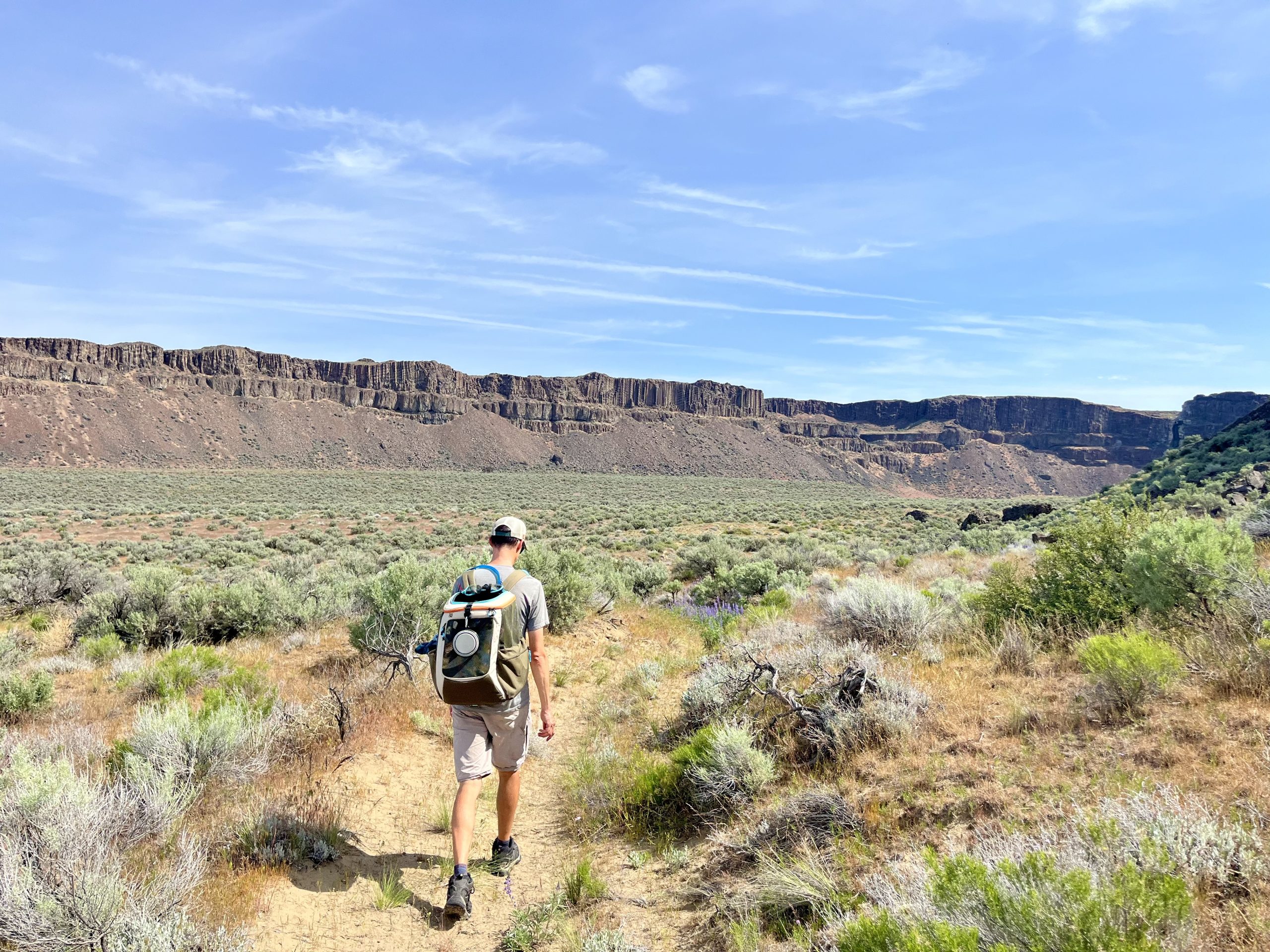
Starting out, we headed up the mesa , which divides Echo Basin and Frenchman Coulee. On the south side of this rocky outcropping is Sunshine Wall, where rock climbers scale the cliffs. We chose the footpath leading up. Somewhere up herer Lucille demanded to be let out of her carrier. As it was early morning, not yet too hot and a lower risk of snakes, she was allowed to walk. If you’ve ever walked a cat on a leash, you’ll likely know it’s more of a stroll with frequent stops. And with Lucille, intermittent requests to be picked up and carried. It’s slow going at best. Not that we minded. The views from the mesa are fantastic. From the top, it’s an impressive drop off straight into Echo Basin to the South and Frenchman Coulee to the North. The mesa itself is nice and wide. Typical scrub land plants, lots of sage brush and grasses intermixed amongst the rocks.

The rocks seem to primarily consist of lava rock and basalt. The cliffsides are mostly basalt columns. In one section on the top of the mesa the basalt looks like giant stepping stones. Reminds me of the Giants Causeway in Ireland. Quite lovely.

There are a few paths on top of the mesa. We chose to head left (or south) toward Echo Basin. Lucille was tucked back into the safety of her carrier prior to our descent. The path leading down from the mesa to the basin floor is steep. Even better, it is composed of loose dirt and rocks. You will likely slip and slide your way down, which can be a little unnerving when you notice just how far you could accidentally slide to the bottom. Lots of side stepping on that way down. Luckily we arrived to the basin floor unscathed.

Once we reached the basin floor we headed directly across its width. Around the other side was our next destination, a sand dune. The trail to the dune is pretty easy, mostly flat. The biggest annoyance is the ground switches from solid and rocky to sand. Hiking in sand is not my favorite. Great ankle workout but rather miserable otherwise. And it definitely gets in your shoes no matter how carefully you tread.

Upon arrival to the sand dune we were impressed with how large it actually was. Admittedly, we set out with low expectations. This dune appeared to flow steeply from the cliff itself, like a sandy waterfall. After walking around a bit, I stayed back with Lucille, who was very over the dune itself and simply wanted to hang in her pack. We sat atop one of the dunes closest to the “waterfall”. Doug ran down the side like a little kid and then ran (yes, he ran) up the other side and eventually made it to the uppermost portion of the sand dune/waterfall. And then he galloped down that one as well. This time with a little less control and a load more arm flailing. Hilarious to watch.

After sitting and enjoying the views for a bit it was time to head out once more. We retraced our steps back to Echo basin and diverted off our earlier path into the basin. The footing was frequently sandy which made the walk a bit of a slog. The path meanders into the basin, first on the south side on what looks to be an old dirt road. There were thousands of purple lupine blooming. One of my most favorite wildflowers. they were gorgeous.

The path eventually turns into more of a single track and crosses toward the center line of the basin. We were headed to the end (or beginning?) of this basin to check out the waterfall and small lake. To get to the lake the trail drops down quite a ways. It’s somewhat of a choose your own adventure as there are multiple paths in the area. Granted, some look more akin to deer trails than human made trails. Regardless, there are options. The lake itself was rather grimy. Algae, winter debris and detritus did not make the near shores appealing. Knowing that our precious cargo was getting a bit toasty in her pack, we headed around the south end of the lake toward the cliffs where there was a large rockfall into the lake. The water looked more appealing on that side. Much less sludgy.

Getting over there was entertaining. We took a goat path, ducked through oversized sagebrush and brambles and scurried over loose rocks and boulders. Bet we were correct. The water was remarkably better on this side. Lucky cat. In she went, rather begrudgingly at first. After a moment she seemed to realize it wasn’t that bad. She was standing on a rock, all paws in the water that didn’t even reach her belly. Her helpful humans made sure her fur got nice and doused. Afterwards she just stood there for quite some time watching the birds and water bugs. As in more than a few minutes. She eventually seemed to realize she was hanging in water and climbed out. And shook like a dog right near Doug. Gave him his own water dousing. Then it was back in the pack and back to the trail. Mosquitoes had figured out we were there and began hunting us like voracious miniature minions of hell. Good time to leave. As for the waterfall, there was none. Must have to be here very early in the season to see one. We only saw a damp cliff wall where I presume the waterfall would be.

The good thing about blood sucking bugs is they are highly motivating in keeping us moving. We climbed that hill out of the lake area at breakneck speed in a desperate attempt to loose the bugs. It did work. After a bit of wheezing we could slow down to a more normal pace. This time, we headed along the north side of the basin. Along its cliffs we could see quite a few rock climbers scaling the basalt features. Entertaining to watch when not looking down at the path to watch my footing to avoid face planting in the dirt. Oh, and watching for snakes of course.

Of note, the path on this side is magically more rock and compacted soil. Lava rock interspersed off and on. Much preferred to sand. There are loads of sagebrush. No lupine. Seems they prefer the sandy side.

From here, we took the trail out to a parking lot, off Vantage Road SW. This one is at the bottom of the basin and coulee. There were only a few vehicles parked here. This is where you’ll cross the road and enter Frenchman coulee. Audios Echo Basin, Hello Frenchman Coulee.

Once again we found ourselves on an old road. For a while it parallels Vantage Rd SW. As we meandered down it, we wondered, not for the first time, just what is a coulee? Later that evening Doug looked it up. Turns out a coulee is a canyon with steep, cliff like walls and a flat bottom. Generally dry or with a small stream. Specifically, coulee’s are believed to have been created by glacial melt. Good to know.

By now it was straight up hot. The humans were hot and sweaty. The cat was damp and relaxed, doing her typical looking about from the comfort of her pack. It was nearing lunch time. We decided to head to the large rock stacks on the north side of the valley floor, mostly in hopes of shade. Also, they looked pretty interesting.

The path to get here is a single track footpath that appears well used. The rock stacks are impressive. Easily 30 feet tall (or higher, I’m a terrible judge) and as big as a cottage. Two are separated by a five foot (approximately) split, which we walked through. On the other side we were blessed with shade. Blissful shade. This would do perfectly.
We plunked down on a flat spot and dug into our lunches. Nothing particularly fancy today. Just a good old peanut butter and jelly sandwich. Don’t have to worry about those getting warm. They taste better warm anyway.

Lucille enjoyed sniffing all over here. Had a Churru treat for lunch, which she devoured with great abandon. Both of us love our food. After a bit, she wanted to explore and we took turns following her around. When we packed up to leave we pulled out the mini fan and set it to blow on her to keep her nice and cool. I could have used a fan to keep me cool. Returning to the brilliant sunshine was a good 10+ degrees warmer.

We headed back to the main trail and kept heading into the coulee. There are a few wrecked vehicles that appear to have gone over the cliffside. Not sure if they were intentional or not but we checked out the first set. There were remnants of three vehicles.

As we continued down the trail we noted quite a few piles of junk. Be it an old car, monitor, high chair, tires , bike or refrigerator. Not exactly in pristine condition with the junk here. If you can overlook the refuse, the scenery is lovely. There’s a legit waterfall at the far northern side of the coulee. Dramatic cliffs make up its walls.

There’s a miniature creek flowing from the waterfall. One conceivably can ascend to the falls via a steep trail up loose soil and rock. We admired it from below and pressed on. The path here is all in the sun, a low grade and steady upward climb out of the canyon. After a bit, we noted there was another creek flowing into the coulee. This one from the very end (or start?) of the canyon. The area surrounding the creek was notably more lush and green. As we neared the end of the coulee, we came into a stand of trees. Meaning shade for a heartbeat until we noticed the mosquitoes. Never mind, we’ll keep going. Shortly after we crossed over the little creek and popped out the other side, back to Vantage Road.

From here we walked along the road until we came to a parking lot/dispersed camping area. Not the one we stayed in with the potties. This one has no restrooms but does have a place to purchase a Discover Pass, which is required to park and camp. They should have toilets in both places. Personal opinion.

We entered the parking area and headed directly for the rock pillars behind it, known as The Feathers. These are a freestanding wall of basalt pillars. One of the pillars is completely freestanding. There’s a gap you can walk through which leads you to the far side of the dispersed camping area next to our starting point earlier in the am.


We headed through the camping area but diverted onto another service road trail. This one lead us past another very busy climbing wall. The trail splits a few times, we pretty much kept heading right. After a bit the trail fades out along a small marshy creek. We paralleled this creek to reach our destination, the top of the “waterfall” of Echo Basin. Found a nice boulder to plop down on and enjoy the view, which is outstanding. Doug looked around and did find the smallest of trickles dropping over the edge of the cliff. Guess it technically counts as a waterfall. Barely. Munched on our remaining snack. After a while, it was time to head back down the trail, retracing our steps back toward the climbing wall.

As we traipsed down the trail, we had a close call with a very agitated slithery rattler. This time it was Doug who initially got WAY to close before noticing it. Why must they blend in quite so well? We truly want nothing to do with snakes. Of any kind really, but especially bad tempered venomous ones. This guy was a big one. Body as thick as my forearm. And coiled. And mad. To both of our absolute horror, this beast slithered backwards, while still mostly coiled and ready to spring, with its head up and looking directly at us. Not pleasant to watch. It slithered into a sage brush and straight up disappeared. As in gone. And we looked for it, from a distance. No snake to be seen. Sweet. New fear of sage brush unlocked. Turns out they could be hosting mega snakes. Lovely. We almost made it a whole day without seeing a snake. I just wonder how many we walked by unwittingly. Our next steps were back to being paranoid and overly cautious.

We had one last stop in mind, a brief offshoot to a small lake. This one was quite lovely and pristine. Granted, you could hear the freeway and intermittent thunderous noises that we suspect were coming from the military lands not far away. There are also a few power lines. Despite that, the lake is very clean and crystal clear. Even had a few trees.

After looking at the lake for a few minutes it was back on the trail. Passed the rock climbers who were merrily still at it and made our way back to the parking lot. Hike complete.

I enjoyed this hike, though if I’m honest, I liked the Echo basin side better. It was more pristine. There was a sand dune and a somewhat grungy lake. The cliff walls were simply gorgeous. The Frenchman Coulee side was pretty but it wasn’t nearly as scenic with paralleling Vantage Road and the remnants of vehicles and miscellaneous trash. The waterfall and those random massive rock stacks were impressive. Should you decide to hike here, do make sure to bring a lot of water. Sunscreen would be advisible if you’re prone to turning tomato red like I do. There’s minimal to no shade for the vast majority of the hike.



Leave a Reply