
CENTRAL WASHINGTON
Summary
A short drive from George, WA lays the Ancient Lakes area. This hiking area is nestled in state recreational lands and presents a great place for spring or fall hiking. Here you’ll find lovely vistas, lakes and waterfalls to enjoy.
Trail Stats
Mileage: 10.39 miles total
Elevation Gain: 1,493 feet
Toilet at trailhead: Yes (dependent on start point)
Sandwich Spots: Yes
Parking: Designated Lots
Mileage/EG from Garmin Watch

Trail Details
Something fascinating that we’ve discovered recently is “free” dispersed camping throughout Washington. “Free” if you’ve purchased a Discover Pass. How we didn’t know about this is beyond me. We dutifully purchased our pass every year for many years and only ever used it as a parking pass. Turns out there are specific “dispersed camping” areas that you can legally camp in with the pass. Came in exceptionally handy on our recent trip to central Washington, where there are a decent amount of these sites.

For our stint in the Ancient Lakes area, we stayed in one of these camping areas. Found a great spot to park our van on a knoll overlooking Quincy Lake, one of the innumerable lakes in the area. Just down the knoll there was a reed filled area with loads of birds, which Lucille enjoyed immensely.

It was here that Lucille nearly inherited a brother. Cat that is. While sitting at the dinette, I looked out the window and saw a big orange cat outside, hunting in the bushes. Saw it pounce and get a mouse. Twice. Lucille freaked out. When that cat walked up the hill toward the van she was hissing and spitting at the window. Tail all poofed out like a crazed maniac. The big orange cat, who I named George Quincy, simply looked up at her as if to say, “the heck is your problem?” I was rather on George’s side.

Now this camping area is in the middle of nowhere. It’s near Quincy, WA. Which is nearish George, WA. Thus naming the cat George Quincy. We were in the middle of the North Columbia Basin State Wildlife Recreation Area. So where did this cat come from? I hoped at first that he (as it was quite obviously a boy cat) simply belonged to one of the campers in the area. Everyone here had an RV, camper or van. Though even this disturbed me a bit. How would you get your cat back?

Turns out George was not a fellow campers cat. Which means he was most likely either someone’s cat that escaped, or he was dumped out there. Both are terrible. I tried to con him close. Put food out for him, which he ate. If I even tried walking in his general direction he bolted. If I could have caught, him Lucille would have a brother, George Quincy. I think Doug was rather relieved the cat was so skittish. It just made me sad. Poor George.

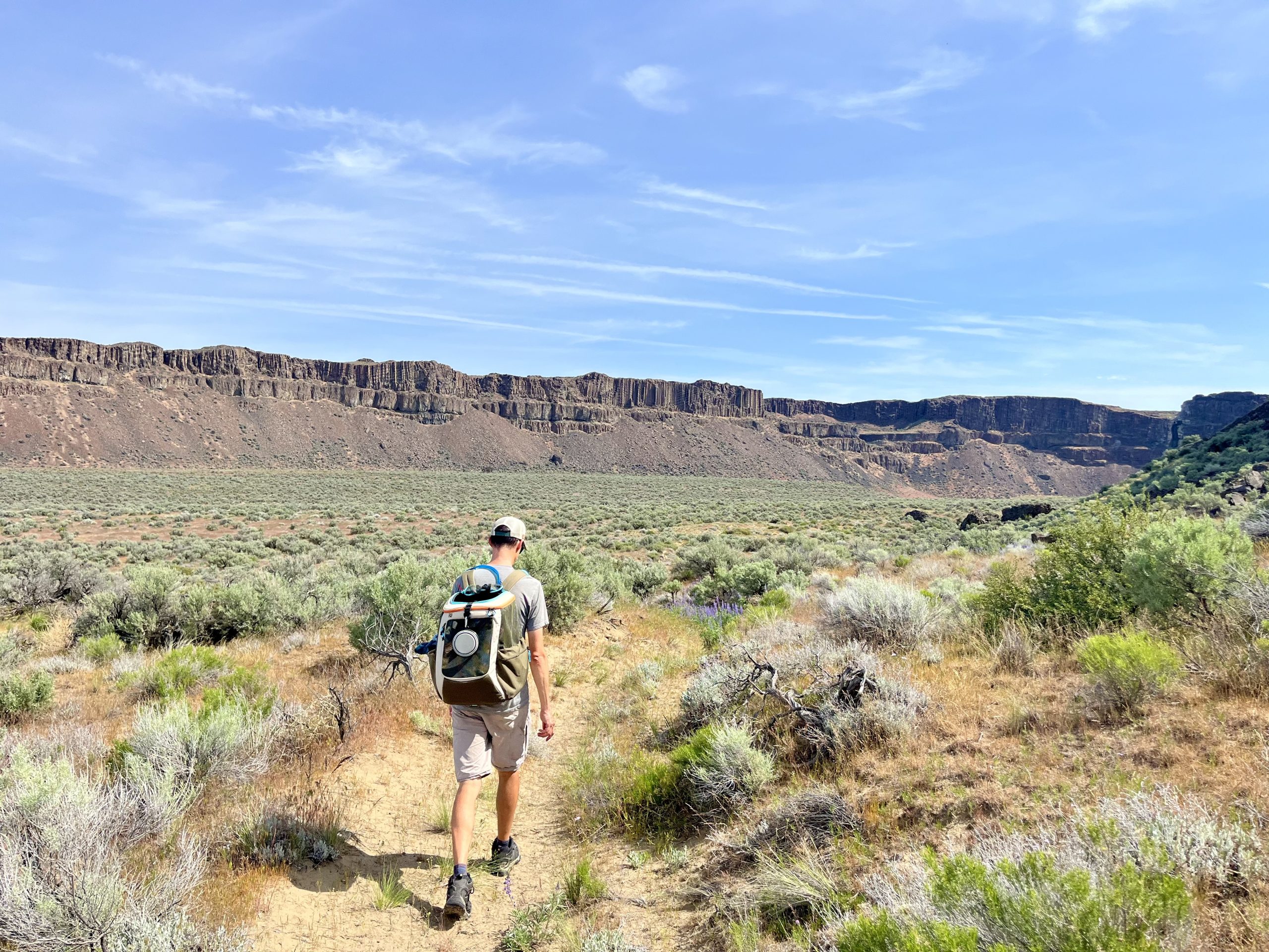
All the sad cat story aside, we began our hike from the camping area. If one was to arrive for a day hike, there are plenty of parking areas to choose from. Some even have vault toilets.

To start, we walked a short distance down the gravel road, heading toward an overlook. The trail for this is across the road from the Burke Lake public access point. There’s a vault toilet, head past that and you’ll find a brief trail to the overlook. It’s relatively flat, through sage brush and well worth the extra few steps. You’ll be rewarded with a fabulous overlook of Dusty Lake and into the Tolley Canyon, both of which you’ll see close up later on.

After you’ve soaked up enough of the view, head back down the trail toward the Burke Lake public access point, turn right and continue down the road for a few paces. There will be a trail off to the right that you want to take. When we were there it was marked with orange tape and started out a tad overgrown. Nothing like pushing through giant sage brush and immediately checking for ticks to start your day. After a few feet the trail improved drastically.

This one starts out flat until you reach a nice little overlook near a rather swampy section. From here the trail drops down toward Dusty Lake and into the canyon. There’s an official trail to the right, you can’t miss the railings along the path. The railings were slight overkill but I suppose they do make the area more accessible.

There are a few small creek crossings along the path. One had a nice, albeit slightly wobbly, wooden bridge to aide in crossing. Another section had flooded its banks and created a soggy marsh. We declined slogging through the ankle deep muck and walked along a rocky ledge to get around. Found a spot to hop across. Of note, there are some rather impressive frogs in here. We startled more than a few, which in turn rather startled us. Lucille found them rather fascinating and required some convincing to move on.

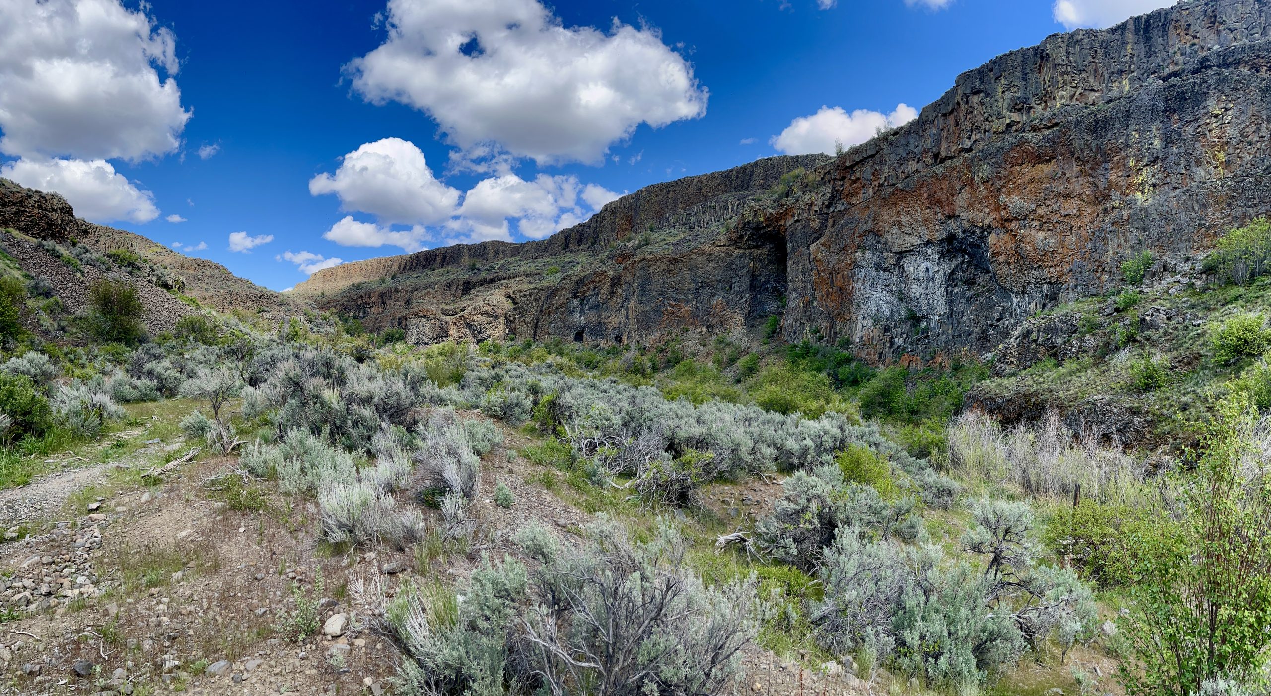
You’re now heading below the ridge of the canyon, meaning there are rather lovely basalt columns you’ll be under. The sheer walls of stone are impressive above the slopes of scree and shale.

Once again the landscape flattens, providing a relatively flat trail through the dry landscape. You’ll walk through this for a while before once again heading down, this time to Dusty Lake itself. The trail does seem to split in quite a few places here, simply head down toward the lake. Not really sure if it matters which path one takes.

Dusty lake is an odd shape. It’s kind of like a “C” or backwards comma with a few random bump outs. All this to say you’ll walk by the lake twice, in different sections. The first section hugs the lake shore, if you can call it that. The trail walks you through the talus field which composes this side of the lake shore. From here you’ll pass over the middle land part of the “C” before dropping back down to the Dusty Lake.

Once we reached the lake again we had to consult our Gaia app. The trail disapeared. The app told us to head along the right shore. I’m fairly certain the trail was either under water OR rocks had fallen down over winter and obscured the path. Ah well. We are not ones to be bested by a few gazillion rocks in our way. We had hiking to do today. Which means we loaded the cat back into her pack (which made her a wee bit angry) and picked our way across the rocky slope. This rocky slope lasts the entirety of the lakes length. We did note what intermittently appeared to be the trail, so I suspect my latter guess as to what happened to the trail was the correct one.

At some point along the lake we realized we had a rather warm cat in a pack and had quite a few miles to go. Handy there’s a lake right here. So, for Lucille’s very first time ever, she got a lake bath. Good thing we have a pretty trusting cat. Once she was nice and soggy, which takes awhile to actually get them wet, it was back in the pack. I did wet a towel for her to sit on and stay cool with. While I can’t particularly say Lucille is a fan of the water, she didn’t seem to overly mind either. Some things are universal across the species I suppose. When hot, water will cool you down nicely. To note, it is not recommended to drink water from the ancient lakes. They are in the middle of farm lands and can have quite a few farm related chemicals in them. If you choose to backpack here (which is popular in the springtime) it’s recommended to pack in your own water or use an extra fancy filtration system that can handle all sorts of chemical pollutants as well as the standard filtering for nasty bugs. And for those of you who worry, Lucille air dried and was not into cleaning herself dry.

After our bathing detour, it was back along the rocks to the outlet. Which was overflowing into a rather healthy creek. Which meant the path across was under water. Not wanting to cross the creek we headed down alongside it. This gave us ample opportunity to watch the marmots running along the banks and rocks. Cute little buggers. Hard to snap a photo of, they would not hold still long enough. After a short ways, we were able to cross without getting our shoes wet. Then it was a quick walk around to return to the official trail.

From here, the path leads west, on the northern side of Tolley Canyon. To note, there are a few other trail options here if you’d prefer to walk down the center of the canyon. You’ll have great views of the canyon walls as you stroll along.

It was shortly after our creek crossing that we ran into two of the three persons we ran into on the trail that day. These were a lovely young couple who were backpacking. They let us know they’d passed a rattlesnake along the path maybe 5-10 minutes prior. We let them know where to continue with the trail unless they preferred swimming. We would run into them again toward the end of the day.

Sure enough, a few minutes later we found the snake. It was a small, very ticked off little guy. Coiled up, and rattled at us before slithering off the trail. I did not care for snakes. Seems the feeling is mutual as it didn’t care for us either. Such an angry little fellow. We were now on high alert for those repulsive reptiles. Luckily, we would encounter no further snakes on the Ancient Lakes trails. Did note quite a few blooming wildflowers. We were here in the end of April.

As we walked along and neared the end of the canyon, there were a few trails one could take. It didn’t seem to particularly matter which one you took as long as you stick in the general direction you plan to go. For us it was walking around to the other side of the hill. There’s a gradual incline through here. Once we rounded the corner and walked in a bit, we stopped under the filtered shade of a giant power line for a brief water break and rest. More because one of us was having that weird eye thing that often results in a full blown migraine. For once it was not me. And luckily after sitting for a bit and downing loads of water, the ocular visions passed without turning into something more sinister. I miss those migraine free days. For both of us.

After our little break we continued on, walking along the southern side of this new canyon, Potholes Coulee. Passed a few rocky mounds that boggled our minds. Why were there random rock tower like stacks here and there along the hillside? I’ve no idea. You’ll have plenty of time to ponder this great mystery as the trail ambles up and down the slopes.


For our lunch break we decided to take an offshoot trail up to the top of the ridge between our current canyon and Tolley canyon. This trail is steep and composed of loose rock and dirt. Not so bad on the way up but a bit of a slip and slide on the track back down. The view up top did not dissapoint. From here we had stunning views overlooking Tolley canyon where we started out and into the Ancient Lakes basin of Potholes Coulee, where we were headed. Gorgeous. The most difficult task was finding a good rock to plop down on and deciding which way to gaze. Toward the top one can see and stand atop the basalt columns. Always fun to see their shape up close and experience how massive these stone structures are.

Lunch today consisted of leftover pizza for me and a boring PB&J sandwich for Doug. Luckily for me Doug won’t eat cold pizza so there was no sharing required. I love pizza in just about any way shape or form. Just no pineapple and Canadian Bacon is disgusting. Anything else weird I can pick off. For this day it was BBQ chicken pizza. Delicious! Lucille had a Churru. It’s her reward and lunch on hikes.


We chose to prolong our journey and headed along the offshoot trail that would take us along and atop the southern canyon wall that we were on. In the far distance, or toward the beginning of the canyon you’ll see the Ancient Lakes as you gradually draw nearer. The path hugs the hillside above the canyon floor. You’ll have great views of those gorgeous basalt walls, this side is more colored with lichen as it’s the shady side of the canyon.

We did head up another offshoot trail to another overlook. Honestly the one we had lunch at was significantly better as you could see more. This one we left with a “meh” feeling.

Just after this subpar viewpoint the trail starts to turn left and head down into the valley. There’s a rather spectacular rock formation with wave like qualities to it that mesmerized us. After this rock, the trail heads down toward the lakes.

There are a few lakes down here. Some were mostly dried out by time we passed through. The trail takes you between a series of lakes. To the left (or west) are the smaller lakes and to the right are the bigger lakes. Ancient Lake is the one on the more northern side of the basin and is the largest one, though sometimes it appears to be two separate lakes if it’s dried out.

There are multiple trail intersections through this area. Meaning you could wander all over the place and really look at each individual lake if you so chose. We decided on a more direct route through the lake area. We could look around and see water all over the place. Lucky for Lucille, she had stayed nice and cool in her pack with her now damp towel and did not require any further dousing. She was rather content to swap between snoozing and looking about. Tough life to be a pampered adventure kitty.

The trail will take you to the far side (north) of Ancient Lake before once again turning toward the head of the canyon. Here the slopes below the rocky walls were a lovely shade of green. The grasses were happy and growing well. Ancient Lake itself was bursting over its shores, some of the small deciduous trees along its banks were partially submerged in its waters. We saw a stork soaking up some sunshine along the hillside. Had our third person of the day pass us, heading in the opposite direction on a bike. Also saw a young bald eagle perched atop one of the trees. We later saw why, the lake is loaded with fish. I don’t think I’ve ever seen that many fish along the shores of a lake before. Hundreds of them lazily swimming amongst the reeds and lake plants.

The trail takes you toward the start of the canyon toward Ancient Lake Falls. Somewhere around here we ran into that backpacking couple again. Chatted about snakes and waterfalls. Nice people.

Then it was up to the waterfalls! While I am not a waterfall lover or admirer by any means (Doug’s the one who loves them), this one was impressive. We’d seen it in the distance for what felt like miles upon miles. Mild exaggeration here, but you could see it in the distance for quite a ways. This one cascades over it’s rocky ledge with enough force and roar to impress before flowing into the lake below. Later in the season I’d imagine it transforms into a lame trickle, but in the spring it’s quite lovely. I found a place to sit, take off my shoes and stick my feet in. Great spot to cool off, numb your feet and enjoy looking back across Ancient Lake and out the canyon. Granted, the spray from the waterfall left me more damp than desired. Dried out quick enough being a nice hot day. Lucille and Doug headed up trail as the crashing of the falls was overwhelming for sensitive kitty ears.

Atop the falls, we followed the path as it winds along, loosely following the creek. It’s basically a marsh up here with ridiculously long grasses, taller than either of us. Do mind your step here, the trail is worn into a slope and in spots, if you misstep, you’ll wind up in the creek.

Somewhere back in here we needed to cross the creek again. The trail was once again under water so we headed uphill a bit, following a relatively obvious trail. Fairly clear we were not the only ones who didn’t want to walk through the boggy marsh. There’s a path through the dense green bushes to a creek crossing where it’s a simple few hops across the rocks to cross.

One major problem. Stinging nettle. The name clearly describes the plant. It’s one of those plants I can’t tell you what it looks like until I see it. And then I second guess myself. What I can tell you with all certainty, is these plants are generally found in dense clumps. They prefer moist soil, often along river (or creek) banks or in nutrient rich soils in wooded areas. They are quite green, can grow rather tall (hip height or so), have serrated leaves and great root systems that allow them to spread rapidly. If you happen to get into them you’ll experience a burning stinging sensation that can last for quite some time. The more exposure and contact, the longer the stinging.

The entire creek bank was encompassed in this nettle. Which Doug, who was leading the charge, walked into. Stinging all over his legs. Remember it was warm, we were in shorts. The nettle was on both sides of this “path” to cross the stream. Path is used lightly as it was not a true path. More like a goat trail. Doug was ready to head back down and out but I managed to cautiously step through without any dire contact and cross unscathed. Doug did follow successfully as well. We really should have know better. We’d come across a small clump of the stuff a short bit earlier and that one zinged both of us, though just a little. That one got my ankle. Lovely plants. Moral to the story? Beware the stinging nettle.

We managed to avoid all further toxic plants as we headed toward Upper Ancient Lake Falls. They really went above and beyond in their names out here. The upper falls are cute and flow from Judith Pool, which you will walk past on the trail. These upper falls are less impressive than the lower Ancient Falls. Judith Pool is a small “pool” of water thats situated at the top of the hill so to speak. While there are some nice gentle hills surrounding , its beauty is marred by the visibility of power lines.

Heading onward we passed more marshy areas before the trail turned right (south). Shortly after we came to a split in the trail. Left would take us to a parking area where we’d have to walk along the main gravel road for quite a ways to reach our vehicle. Right would take us toward H Lake with a small marshy creek crossing to the H Lake Water Access point where we’d walk down the access road, to the main gravel road, which is named Road T Northwest by the way. Again. Great names.

Naturally we chose to head right. Who wants to walk along a road when you can walk along a more serene path? Certainly not us. Now H lake is fed by the significantly larger Stan Coffin Lake. Stan Coffin is large enough to have a legit boat ramp, for reference to size. As we walked along we began to notice what could be a small problem. Ahead, the marshy area seemed quite overly marshy. As in the trail looked obscured. We turned off trail to see if we could cross further back from H lake. Nope. Straight up flooded marsh land. Not wanting to double back, we decided to take our chances and continue back to the H Lake water access parking area.

As it turns out, we were in fact 100% correct. The small creek crossing was beyond flooded. It more resembled a small lake than a creek. Bummer that. As we pondered and looked around, we noted there were no convenient stones to cross its breadth. This one was quite wide. Probably 20 plus feet of marsh, muck and water. The first section to cross had what appeared to either be a dense collection of march reeds and grasses or a beaver dam across it. We tentatively made our way across the dam, being ever careful with our steps as some would sink into the yuck below. I gladly let Doug cross first.

This let us out onto a small “island” of reeds and mud. Island meaning that it had enough space for both sets of our feet. This led us to the next bit of crossing. Here we realized one truth, there was no way across without getting our feet wet. Off came the shoes, during which I nearly fell backward into the swamp. Kindly remember there was no extra room on that bit of relative dry land.
Once again Doug led the way. Our path across the few watery feet was selected, there appeared to be a bar across which would make for a less deep crossing. Perfect. Would have rather rock hopped across but there were only rocks on the far side, significantly further than either of us can jump by more than a few feet.

Doug committed and took his first step out. And sunk to his ankle. Eww. So much for a solid bar to walk across. In the words of my dear friend’s young daughter, the substance our flesh sunk into can only be described as “icky sticky.” Truer words have never been spoken. It was repulsive. Once safely on the other side, we sat upon the rocks, washed off the icky sticky, and put our shoes back on.

From here it was all walking along gravel roads. First down H Lake Water Access Road. Then turn right onto Road T NW which would take us back to the Quincy Lake water access parking area and dispersed camping. Which is where we started our journey. End of trail.

We found the Ancient Lakes area to be quite enjoyable. I’m not quite certain how people make it into a backpacking trip. We seemed to see nearly everything in the area in a day hike. I know there’s a way to walk down into the Columbia River Gorge from here. That might make it long enough to backpack.

As a day hike, we couldn’t have been more pleased with the variety this trail system gives. Plenty of overlooks and viewpoints. Loads of lakes and a few waterfalls. Could the trail have been in better condition? Yes, in places. As long as you aren’t afraid to travel in the general direction a trail is headed, it’s quite passable. If you go in springtime know there may be a few soggy crossings or trail rerouting to avoid a soggy crossing. Much later in the year would make this trail system remarkably hot as it’s frequently in the 90’s and there’s very little overall shade.


Leave a Reply