WESTERN WASHINGTON
Summary
One could spend weeks exploring the Alpine Lakes Wilderness. The area is as advertised, full of lakes. The views are sure to impress, from high vistas and lush forests.
Trail Stats
Mileage: 11.2 miles one way
Elevation Gain: 3,442 feet
Toilet at trailhead: Yes* trail toilet
Sandwich Spots: Yes
Parking: N/A
Mileage/EG from Garmin Watch


Trail Details
Last summer, we failed in enjoying the great outdoors, largely due to non stop working on our adventure van. In a way, it felt like a wasted summer. This year we are striving to make up for it. And finish the van. So, we are insanely busy all the time. But this year, theres a lot of fun things mixed in. Like backpacking. This was our third backpacking trip of the year. First we explored Hells Canyon, then our failed Kettle Crest trip. For our third adventure, the Alpine Lakes Wilderness was selected. An area we are rather familiar with and have hiked in quite a bit.

Early one morning, we loaded up and hit the road for a 4+ hour drive to the Ira Springs trailhead off I90 in the Snoqualmie Pass area. Day one entailed hiking to Mason Lake, where we pitched camp under delightfully sunny skies. From there we headed up one of my favorite hills, Mount Defiance. The views are well worth the climb. We soaked in the scenery before heading back to camp and settling in for the night. Previously, we’ve done Mt Defiance as a day hike. To read about the hike from the Ira Springs Traihead, click here.

On to day two of our trip. Woke up to the peaceful chirping of birds and sunshine. Followed by the less appealing sound of our alarm, signaling it was time to move.

After packing everything up it was time to hit the trails. The path takes you along the lake briefly before diverting into the woods. We realized this was the first time we’d ever been down here when there wasn’t snow covering this entire section of trail. Much easier to stay on the correct route when you can actually see it.

Very soon, the trail spits you out into a T intersection. Left takes you toward Mt Defiance. We headed right toward Pratt Lake. As you walk along here, there are peek-a-boo views over to Mt Defiance. The trail quickly steepens rather dramatically and had us huffing and puffing up the hill. Both of us were grumpy about that hill. No coffee and a steep hill first thing. For some reason we had it in our heads the trail would be relatively flat for a bit. No such luck. We are too slow in packing up camp to stop and have a hot meal and coffee. So it’s a breakfast bar or cookie to go for Doug and a handful of chocolate covered espresso beans for the both of us every morning.

After cresting the hill, you’ll head down a bit. There are some massive boulders around here. Soon Sir Richard’s Pond comes into view. The pond is rather large and comes complete with a few lilly pads. This general area has a lot of standing water. Small marshy areas are here and there. All that to say the mosquitoes were horrendous. We swatted our way through this relatively flat section with great haste.

The trail takes you around the pond. The heather was in bloom and quite pretty. Beyond the pond, we walked uphill a bit before heading down into the trees once again. Crossed a petite stream. Passed Rainbow Lake where we had to stop for a photo. Noted a few nice campsites along the lake. Would certainly be a less crowded option than Mason Lake. Most day hikers don’t seem to visit the lakes beyond Mason Lake from the Ira Springs trailhead.

After Rainbow Lake, the trail moseys up and down some hills. We crossed over a few streams. There’s a signed offshoot trail for Island Lake. We decided to check it out. This path takes you downhill for a bit before wandering past a few marshy ponds. Luckily, there did not seem to be as many ravenous bugs through here. Then the trail takes you along a ridge. From here you can glimpse Talapus Lake, far below. Then the trail rapidly takes you down to Island Lake itself.

Island Lake is quaint. Has a few tiny islands on it. It’s surrounded by tree covered hills. There are some excellent camping sites here. There was also no one around. I took the opportunity to change into shorts. It was way too warm for hiking in pants. Did manage to scare the living daylights out of a squirrel. Apparently I was sitting on a rock above its home while putting my shoes back on. Shot out from under that rock like a bat out of hell. Certainly startled me as well.

Heading back uphill we noted a trail toilet on the ridge. This one was nice. Essentially a wooden box over a pit. Complete with a wooden cover over the “seat”. I’ve experienced a few of these toilets where the wooden platform felt rotten under my shoes. Nothing quite like the fear of falling through rotten boards into a trail loo. That would be a bad day. I’ve even seen one such potty completely collapsed in on itself. We declined to use that particular toilet. This one was relatively new and the boards had no give. Sadly it did not have extensive views overlooking Talapus Lake. They kept the potty in the trees. However, there is a path leading beyond the toilet. Naturally I took it and was rewarded with the best view of Talapus Lake that we would get. Worth wandering past the privy for sure.

After exploring Island Lake, it was back to the main trail. There are rock fields off and on as we walked uphill. As we began our descent, we were way above the Talapus Lake basin. There were views of the surrounding mountains. We could see back toward the ridge by Island Lake. Maybe thats why they kept the potty in the woods. Though one would have to have hawk like vision to pick out someone using the toilet way over there.

There are switchbacks as you head down. Had intermittent peek-a-boo views of Mt Rainier. After a bit you’ll be walking atop a tree covered ridge line. When you come to the trail intersection, take a left and head toward Pratt Lake.

Here the trail simply heads down for quite a distance. There are large rocky sections to cut across. The views from these sections are impressive. The trail drops you into the woods where you’ll descend at a gradual pace. Crossed a few creeks. Parts of the trail are elevated in here, presumably to keep our feet dry when the area is a spring time swampy mess.

Once we reached the lake, it was time to find a spot to sit. There are two rocky sections along the lake with large boulders to sit on. I prefer the view from the second section, which is just a few paces further. Here we climbed up on a rock and enjoyed breakfast. Well, second breakfast for Doug. I think he’s a giant Hobbit.

The trail skirts the eastern side of Pratt Lake. You’ll be walking well above the lake. We noted some massive ferns along the walk. You’ll stay above the water until dropping down to the outlet at the northern side of the lake. Here is where you may gain access to Pratt Lake.

Continuing on, we noted some decently flat sites for a tent along the trail. Presumably there are some off trail as well. Soon the trail splits, left will take you along the Pratt River trail. We headed right for Melakwa Lake.

From here, it’s walking amongst the trees as you head uphill. There are views of the surrounding peaks and into the Pratt River valley. It’s quite lovely. After a bit the path ambles down. There are giant ferns and rocky slopes. The ferns are insane. Some were taller than I am.

After a bit you’ll notice the sounds of Tuscohatchie Creek below you. It’s surprisingly loud, though rather impossible to glimpse. Once you reach Tuscohatchie Lake, there’s a nice little camp site directly by the outlet. Not the most private spot but it’s otherwise just about perfect. There are other sites around the lake as well.

The trail crosses the outlet via a rather dilapidated bridge. There’s a pretty decent array of logs stuck in the outlet, making it an easy walk out onto the lake. Select your log and out you go. Made for the best scenic photo spot of the lake itself.

After walking a bit, theres a small offshoot trail for Lake Kaleetan. We never made it out to that particular lake. Have heard the trail is overgrown in places.

Next, we walked up a gentle grade. Had intermittent views through the trees. In parts the slopes were rocky. Here the trail began to get quite overgrown intermittently. After a bit of wading through the plants, we found there were great views of the surrounding landscape further up the trail. The trail was thickly overgrown with spikey salmon berries and all manner of plants. Parts of the trail were missing down the mountainside in foot sized chunks. This section was not in the best shape.

Ahead of us was a head wall. With a groan we realized our destination was atop that wall. Up we went again. This time through the woods via a few switchbacks. At the bend in one of these switchbacks, we found ourselves above the Pratt River, which begins at Melakwa Lake. Or at least I think it does.

After winding up through the switchbacks, the trail comes to a split. Turning right will take you down to the Denny Creek trailhead. We turned left and headed the short remaining distance to Melakwa Lake.

We were not the only ones at the lake. A gentleman and his two sons happily sat atop a boulder overlooking the lake while munching on pizza. A group of young guys was clearly heard galavanting up and around the east side of the lake. A lady and her trusty dog walked ahead of us on the path.

The trail took us along the western side of the lake. Part of the trail appears to have been blasted out of sheer rock. Footing is a far cry from flat. There are a few rock slabs to walk down. The lady in front of us slid down one rock and nearly slid off the trail entirely.

Toward the northern end of the lake, the trail splits again. The left trail heads toward Upper Melakwa Lake. We took a right as we planned to camp here overnight and needed to find the designated camp sites. Cross the outlet of Upper Melakwa and circle back toward Melakwa Lake. There are plenty of sites to choose from. None would be great if it happened to rain much.

We selected the site directly under the posted camp sign. Here I stopped my watch as we set up camp. I’d restart it when we began our trek to the pass. For now it was time to set up shop. Up went the tent. In went the sleeping pads and bags. Hung our food bag in a great tree. Sat down for lunch. I’ll note, I had to change back into pants and grab my rain jacket to stay warm. The temperature had dropped and it was a tad windy here. Nothing terrible, just not shorts weather.

After lunch, we switched out our big packs for day packs. Much better. Shoved in a snack and water and we were off once again. This time our destination was Melakwa Pass.

Starting from our camp site, we headed north toward upper Melakwa Lake. The two lakes are connected by a minuscule strip of land. It’s not a far walk. Upper Melakwa Lake was rather uninspiring. Its tiny. More like a pond than a lake. But it is nestled at the foot of some impressive talus fields from the surrounding mountains. So at least it’s pretty.

The trail up to Melakwa Pass is unmaintained. It starts out skirting to the right (east) of Upper Melakwa on a fairly obvious trail. Soon after the lake, the trail dithers out completely and you’re on your own. No worries. Look up to the saddle. That’s where you’re headed. Pick your own adventure. You’ll be walking through talus for the majority of the climb. Sadly, on the far end of Upper Melakwa Lake it started to rain on us. The rain was NOT supposed to arrive until the next day. Dang early rain.

To start out after the path disappeared, we headed to the creek bed and followed it up through a tree’d section. The creek bed was easily navigable and provided a great route up.

At the end of the trees, we popped out into a relatively flat wonderland filled with small pools of water and oodles of moss veiled the rocks and boulders. Gorgeous through here. Like something out of a fairy tale.

Somewhere amongst the rocks, we heard the tell tale “meep” of a Pika. If you’ve ever heard this sound it’s instantly recognizable. These small rotund critters are frequently found in high altitude talus fields, like the one we were in. Doug likens their appearance to “little fuzzy potatoes.” I’d add they have adorable ears. Apparently they are related to rabbits. They look nothing like bunnies or hares. Doug’s description is more accurate. Round fuzzy potatoes. With lots to say and always busy stashing away food. They always seem to be on the move.

From here you can climb upward whichever way you so choose. Looking directly ahead there are large boulders and a somewhat sheer rock face splitting the slope. There are trees above the boulders and leading to the top of the saddle. We chose to head to the right of this section as it looked less steep and more easily passable.

To get to close enough to those boulders, we picked our way slowly through the talus. By now it was dumping rain on us, making a few of the rocks rather slick. I will admit I held no real gratitude for the rain. Yes, I know it was a dry winter and we were already seeing multiple fires in JUNE and the rain would be good for fire reduction. I was just not pleased to be IN the rain on my trip. It has rained on every backpacking trip this year, thus far. Lame.

Once we approached the boulders, we were able to hug the tree line for most of the remaining way up. Popping out onto the saddle, known as Melakwa Pass, we were instantly rewarded for our efforts. Sure, behind us we could see Melakwa Lake. It was pretty. But on the other side it was riveting.

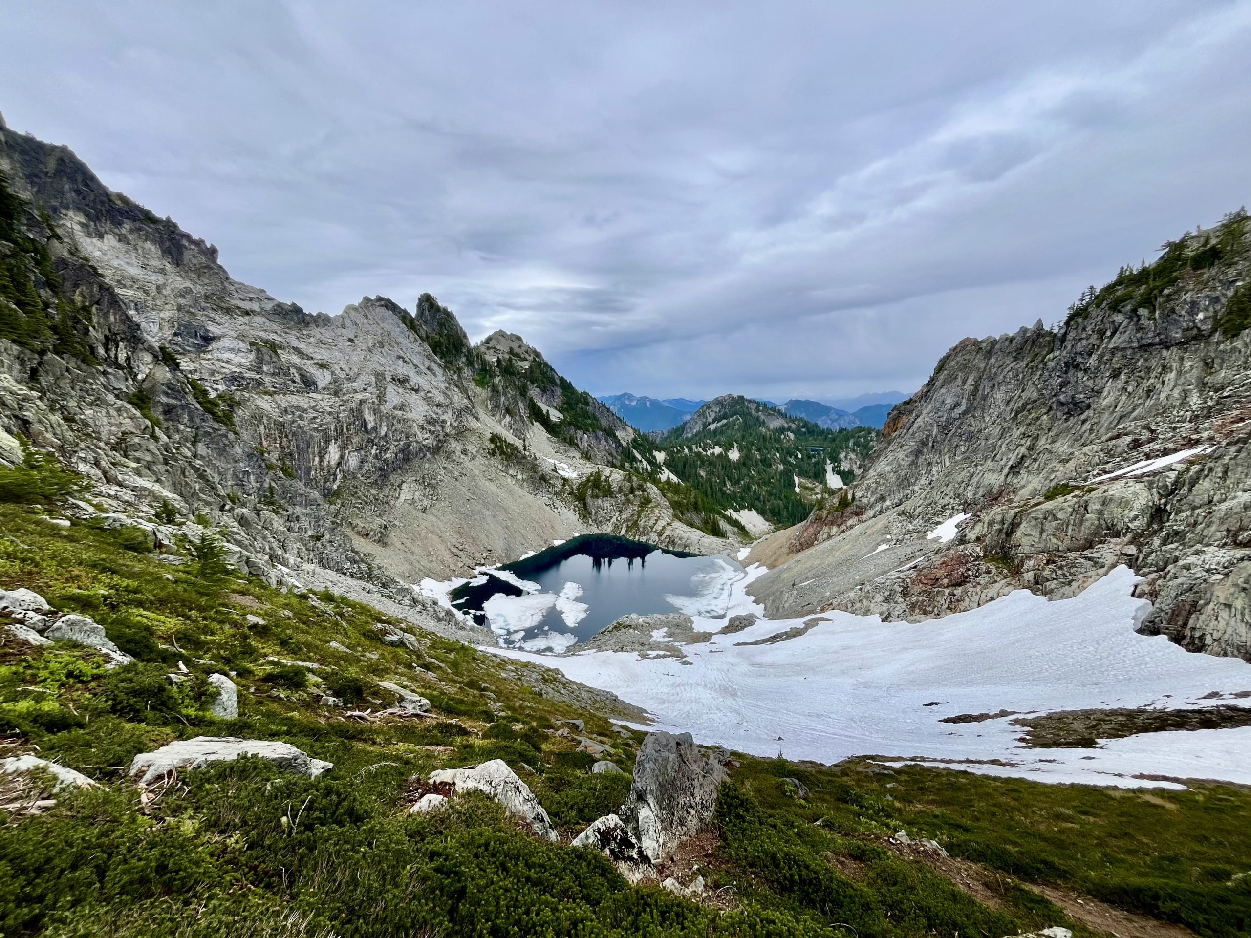
Chair Peak Lake lay far below us, nestled in the base of the surrounding slopes. Kaleetan Peak lay to the west. Mt Roosevelt lay behind Chair Peak Lake to the northwest. Snow covered most of the slope down to the lake from the pass. Ice remained on the lake, partially covering its waters. In the distance, Gem Lake was visible and we could even make out Glacier Peak to the north. The effect was captivating. This view represents why I love hiking. The astonishing beauty of the world we live in. I could stare out in absolute wonder for quite some time.

Speaking of curiosities, there was a group of three down by Chair Peak Lakes outlet. It was rather obvious they had descended from Melakwa Pass. We could see their trail through the steep snow field below us and where they skirted the eastern side of the lake, across the snow. This section by the lake was covered in snow against a steep talus field. They had kept high on the snow to avoid ending up in the lake. These three hung around the outlet for a while before heading up the hillside next to it and disappearing into the areas beyond. We never saw them again. Presumably they either hiked out ridiculously late when we were already tucked into our tent, they stayed out there (they had smallish packs) OR they knew a way out through those valleys. To my knowledge, there’s no trail to Chair Peak Lake. Nothing comes up on our maps. When I looked later on, there’s a possibility they stayed high in the valley and somehow connected into the unmaintained trails leading to Gem Lake. From Gem Lake, they’d be connected into the High-Lakes trail system. It’s possible they knew a way to connect through. Regardless of where they actually went, it gave us something to ponder for quite some time. No way I’d head down that snow field to Chair Peak Lake. That sucker was STEEP.

We sat atop the pass for quite some time. Ate our afternoon snack. Soaked in the view. The rain slacked off, which was nice. Eventually it was time to depart. Retracing our general steps back down the pass was entertaining. Going down a talus field is so much worse than up. The rocks seem so much more inclined to wobble as you step down.

We slowly picked our way back through the talus fields, down the creek bed and back along Upper Melakwa. Reaching camp, we settled on an early dinner as it was not raining. Managed to mostly finish and prep for the night before the rain returned. Ducked into our tent and played a few rounds of cards until drifting off to sleep.

I’d like to say I peacefully slumbered to dreams of the day’s adventures. In truth, sleeping on the ground had me alternating between side sleeping, where I’d awaken with hip pain, and laying supine until I woke with numb arms. Neither was great. Oh well. I did have enough awake time to stare into the darkness and reminisce. We enjoyed the days hike. Stunning scenery. Lakes. Mountain. Passes. Could have done without the bugs and rain but otherwise it was fabulous. I’d absolutely recommend this one.


Leave a Reply